Major Improvements to CRESTA Map Viewer
CRESTA, the insurance industry organisation providing a standard global system of risk accumulation zones, has announced today the release of a new version of its online CRESTA Map Viewer which includes a number of significant enhancements. The Map Viewer is available to the public at app.cresta.org.
Since the launch of the 2019 CRESTA Zones together with a new CRESTA website in October 2019, CRESTA has received valuable feedback from numerous industry practitioners and CRESTA users. This feedback has been incorporated into the new CRESTA Map Viewer.
The updated Map Viewer offers a range of innovative features designed to improve the user experience and the overall performance of the tool:
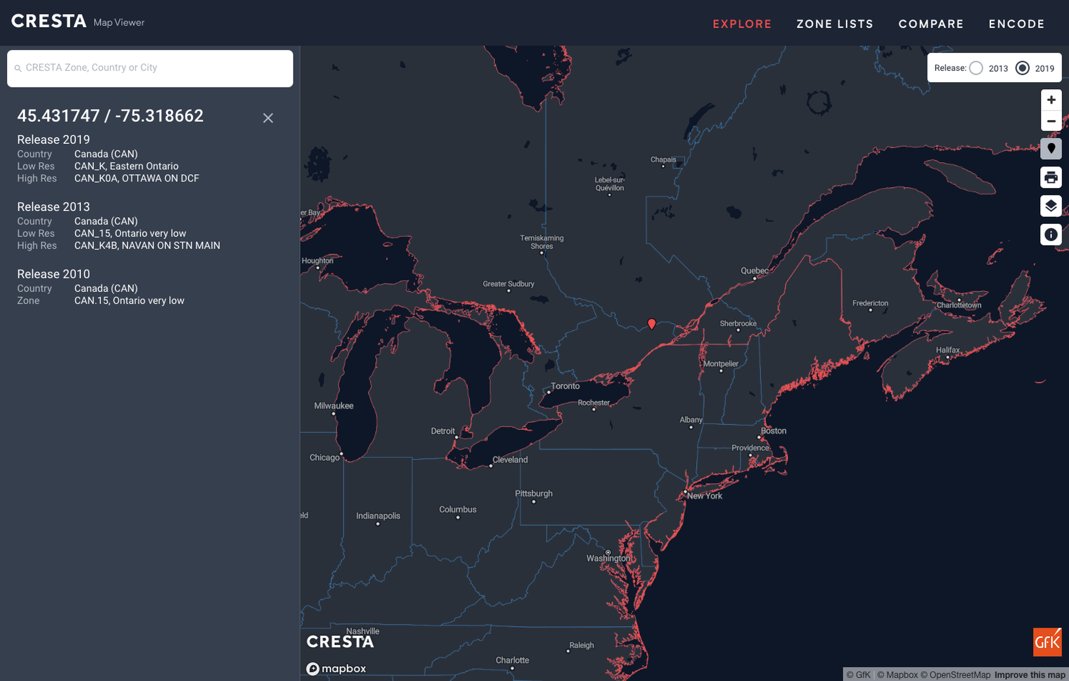
- A new ‘Identify’ function displays CRESTA Zone information for a selected point on the map. The information includes low- and high-resolution zone IDs for CRESTA Releases 2010, 2013 and 2019 (see illustration below). Latitude and longitude for the selected point are also shown.
- A smart new search algorithm turns the search function into a powerful tool to directly access information at the country and CRESTA-Zone level. It also allows users to search based on an extensive list of populated locations worldwide.
- The new map styling is optimised for better readability. The inclusion of bright and dark modes helps to illustrate distinctive zone borders, suitable for screenshots and printouts. Additional zoom levels enable users to access data down to street level.
- A new print function allows users to export the active map extent as a PDF for printing.
The CRESTA Map Viewer also includes a number of system upgrades and delivers improved country border definitions, as well as introducing minor amendments to existing zones in Azerbaijan, East Timor and Ireland. For more details on these changes, please consult the News section under the respective country.
With the launch of its improved Map Viewer, CRESTA further strengthens its position as the global risk accumulation zoning standard. Moving forward, CRESTA will continue to engage with the industry to enhance the value of the CRESTA standard.
For more information please visit cresta.org. To provide any feedback or pose questions on the CRESTA Map Viewer, please email cresta@perils.org.
About CRESTA
The CRESTA organisation was established by the insurance and reinsurance industry in 1977 as an independent body for the technical management of natural catastrophe insurance. Its manager is PERILS CRESTA AG, a subsidiary of Zurich-based PERILS AG. CRESTA's main goal is to establish and maintain a uniform global system for the exchange, comparison, visualization and modelling of aggregated insurance data used for risk accumulation control and risk assessment, among other uses. Over time, CRESTA will add other services increasing standardization, efficiency and data availability to the benefit of the insurance industry.
More information on CRESTA can be found on cresta.org
About PERILS
PERILS is an independent Zurich-based organisation providing industry-wide natural catastrophe exposure and event loss data. The PERILS Industry Exposure & Loss Database is available to all interested parties via annual subscription. The database contains industry property sums insured and event loss information on a CRESTA zone level and per property line of business. PERILS industry loss estimates provided via the PERILS Industry Loss Index Service can be used as triggers in insurance risk transactions such as industry loss warranty contracts (ILW) or insurance-linked securities (ILS). The service currently covers the following 16 countries: Australia, Austria, Belgium, Canada, Denmark, France, Germany, Ireland, Italy, Luxembourg, the Netherlands, Norway, Sweden, Switzerland, Turkey, and the United Kingdom. The use of PERILS exposure and loss data other than in conjunction with a valid PERILS License and according to its terms, by a Licensee or an Authorized User as defined in the License, is illegal and expressly forbidden.
More information on PERILS can be found on perils.org